
Case Study: Using data to determine bush fire ignitions and predict causes
Statistical modelling can quickly predict the cause of a bush fire.
Statistical modelling developed by a team led by Professor Di Cook can quickly predict the cause of a bush fire by combining satellite data with other sources of information.
Di and her team used the modelling to dispel claims that arson was to blame for many bush fires from the terrible summer of 2019-20.
“Despite prolonged drought conditions and climate change only getting worse, a lot of people, including political leaders, tried to steer the debate on social media away from climate change and instead blame arsonists,” says Di, a Professor in the School of Econometrics and Business Statistics at Monash University and an Associate Investigator with ACEMS.
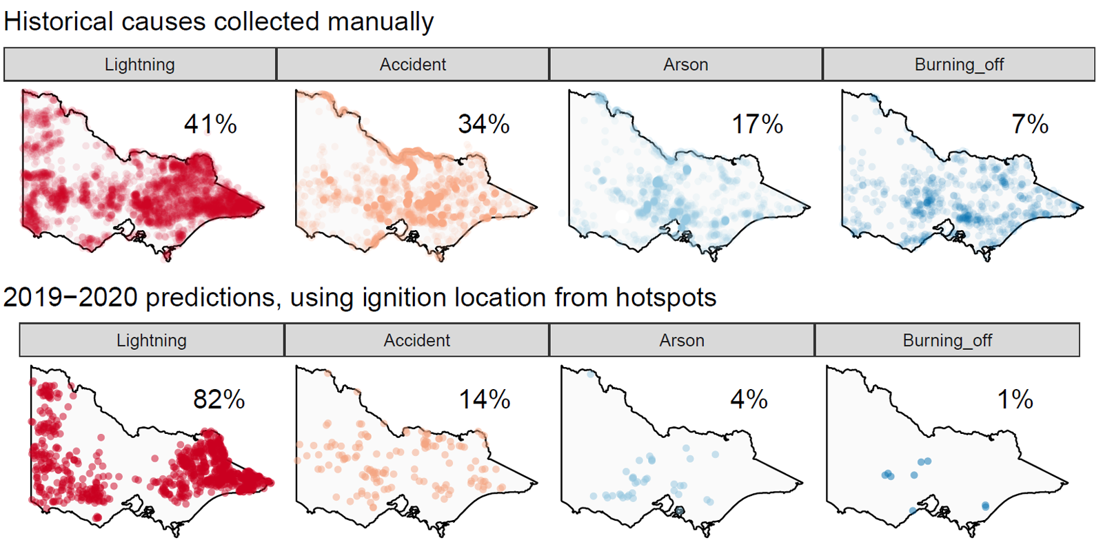
“Our analysis showed that arson could only be blamed for four per cent of the bush fires in Victoria.”
On the other hand, their analysis showed that lightning sparked more than 80 per cent of the Victorian bush fires.
To create the model, Di worked with Weihao (Patrick) Li, an Honours student she was supervising at Monash, and Emily Dodwell, who was a Principal Inventive Scientist at AT&T Labs Research in New York. ACEMS funded Emily’s travel to Australia to begin the project.
The team started by taking hotspot data from the Himawari-8 satellite, which shows heat source locations over time and space, and filtered out hotspots that were unlikely to be bush fires.
“We then used our new data mining algorithm to do spatiotemporal clustering where we introduce a time dimension to geographic data to estimate ignition time and location,” says Di.
They supplemented that information with data from other sources like temperature, rainfall, wind, fuel load, and distance to campsites, roads, and Country Fire Authority (CFA) stations.
The next step was to ‘train’ their model using historical data. They used a machine-learning algorithm called a random forest to analyse historical bushfire data from Victoria’s Department of Environment, Land, Water and Planning from 2000 through the summer of 2018-19.
Their model performed well on the historical data, with 90% accuracy (true positives) on lightning-caused fires and 78% accuracy on accident-caused fires. For arson-caused fires the model was 54% accurate, but when it was wrong it was because it predicted the cause to be an accident. It makes sense that arson would be confused with accident.
“We found that the most important contributors to distinguishing between lightning and arson or accident ignition were distance to CFA stations, roads and campsites, and average wind speed."
“If the distance was small and it was windy, it meant the fire was most likely caused by arson or accident. For longer distances where the location was mostly inaccessible to the public, the model predicted lightning to be the cause.”
The trained model was applied to the 2019-2020 fires to predict their cause based on the ignition location estimates. It suggests that 82% of the fires could be attributed to lightning, 14% to accidents and 4% to arson.
“The proportion of lightning fires was twice as high as with historical data, which makes sense because the hotspot data can detect fires in remote location where we have little access,” says Di.
Di says their analysis uses open-data and open-source software. She hopes it will be applied to fires elsewhere in Australia.
“We plan to publish our algorithm as an R package called spotoroo so other researchers can detect fires more effectively,” says Di. (The development version of spotoroo can be previewed at https://github.com/TengMCing/spotoroo)
The team also developed an app to help you explore historical fire data and their predictions for 2019-20 bushfires.
The People

Di Cook, Emily Dodwell, Patrick Li

Di Cook & Emily Dodwell at a cricket match during Emily's visit to Australia
Causes of fires from 2000-2019. Lightning is most common cause. The number of fires is increasing, and this is mostly due to accidents.
Spatial distribution of causes of fires from 2000-2019, and predictions for 2019-2020 season.
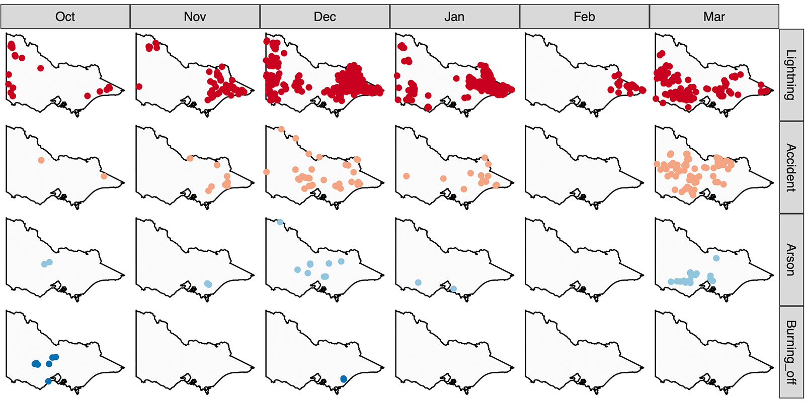
Spatio-temporal distribution of cause predictions for 2019-2020 season. Reassuringly, fires due to burning off primarily occurred in October, prior to fire restrictions. February fires were all predicted to be due to lightning.